SLED charges two people, years after body found in sewer
Greenville City Fire respond to brush fire near Swamp Rabbit Trail
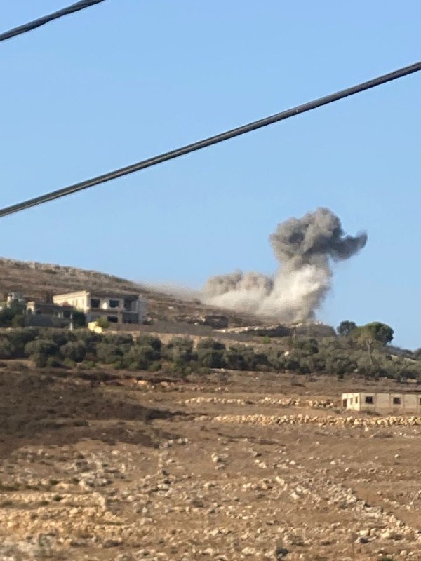
A wildfire was reported active on Enoch Road Thursday, around nine miles north of Conway
North Charleston Police investigate early-morning killing
Two people were arrested after a shooting in the Plum Branch community in McCormick County
Crews responding to house fire in Greer
Coroner responding after body found outside home in Anderson
Investigation continues in fatal shooting of 7 dogs in Georgetown Co
Deputies investigating deadly Summerville shooting
Deadly car crash under investigation in Upstate
 2 Monat zuvor
Man dies after shooting behind gas station on Carowinds Blvd in York County
Parents accused of killing their 7-month-old in South Carolina arrest months after infant’s death
9 charged in shooting, crash that left two Upstate brothers dead along I-385, police say
Greenville police find gunshot victim; search on for possible suspect, officers say
Juvenile hurt in Greenville County shooting, deputies say
Employee shot at Upstate store, deputies say
1 arrested in connection with Rock Hill shooting
One person killed in Upstate crash, coroner confirms
Man dies after being hit by a SUV in a Gaffney Walmart parking lot
North Myrtle Beach Police Department and a towing company are on the scene at the corner of Ashley Loop and Diatra Lane
Large police presence spotted at Rock Hill apartment complex
Motorcyclist killed in Spartanburg County crash identified
Greenville man headed to prison after 18-year-old woman found dead
Suspect captured after shooting at Walmart, officers say
Man hurt after shooting at house party in Anderson, deputies say
'Wanted person' in custody after Myrtle Beach investigation, police say
The boy was found with multiple stab wounds
Beaufort Police investigating apartment complex shooting
Pedestrian dies in hit-and-run crash, coroner says
2 dead in Florence collision on West John Paul Jones Road near Cummings Road
South Carolina news on live map
Colors on the map
 U.S gov
 Authoritarian countries, far-right, far-left groups, and Donald Trump
 Terrorists and criminals
 Non-government organizations and groups
 Non-aligned, Nature
 Solar eclipse on 21 August
Path of solar eclipse on 21 August Areas
Blizzard/Winter storm warning Icons
 Straße, Unfälle, Autos
Artrillerie, MLRS Flugzeuge, Jets Hubschraubers Lages, Zelle Gefangen Getötet Messerstecherei Angriffe Feuers Verletzt, Medikamente Brandflaschen Polizei Schießen Ansprache, Aussage blockierte Straße Tanks, APCs, bewaffnete Fahrzeuge Schlägers, Menschen in Masken Strahlungsträger Schiffe, Kriegschiffe Gas, chemical weapons Drohnen, Roboten Rallyes, Proteste, Demonstrationen, Menge Geiseln und Flüchtlinge keine Verbindung, Leitungsrauschen, Funkmeßortungsgerät Gewehrpistole, bewaffnete Männer Explosionen Anschlage LKWs Hackers, Computers Bilder Nährung Geld Presse Handy Befestigungsanlage Video Zerstörung Landminen, selbstgemacht Sprengstoffe Aufbau Einsenbahn Haus Flugzeugabwehr Keine Wasser Rakete U-Boot Twitter Facebook Stromausfall Biohazard Naturkatastrophe Börsen Transport or civil plane Rettung-Operation natürliche Ressource mobile Anwendungen Drogen Erdbeben Überschwemmungen Tsunami Tiere, wilde Natur Sport Karte Vulkan Schnee Pollution Manpads Korruption Satellite Alcohol Arrested Sun Bus Animals: Cat Animals: Dog Stocks Down Animals: Snake ATGM Animals: Panda(rare animals) Animals: Horse Animals: Cow Animals: Lion Animals: Shark Animals: Wolf Supply Flares Animals: Bear Machine Gun Stun grenade Airplanes: light plane Motobike Balloon Bulldozer Cruise Missile FPV drone Map Change Event Missile Airborne Quadcopter(Mavic) Large explosive drone(Shahed) Tractor Tunnel Air Alert Aerostat, High-Altitude balloon Attention! All events and areas of control on the map are geolocated approximately